Snap to point
Snap to point enables you to switch on digital data points that Ordnance Survey supply on a detail layer map. This means you can measure the exact distance from one point to another and the area or perimeter of a site.
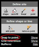
The tool can be found in the left-hand side of the screen:
Click the word Show provided to see the digital data points. You will see several white and orange points appear on your mapping. These are the digital data points. The orange points denote the beginning of lines, end of lines and a change in the map feature while the white points indicate other changes in the lines. For measurements to be accurate you should use all the points indicated no matter what colour they are.
Once you have clicked on Show you will notice that it toggles to Hide. To conceal the points click Hide.
These points need to be used in conjunction with other tools, e.g. the shape or line tool to enable you to get an accurate measurement from Envirocheck.
Tip
|
Dealing with numerous snapping points
By holding down the space bar, the points in-between the two that you click will be picked up automatically. The line snaps to the nearest map feature or digital data point automatically. However, if there is an orange point in-between, you will not be able to snap to the line, as there is a change in the map feature. In this case you must click to the nearest white point before the orange point, then the next white point to wherever you want the end of the line to be.
|
Next: Grid reference


 Call our Technical Support on 0844 844 9961